Khosar Gang Expedition 6,040 m
- 17 days, Islamabad to Islamabad
- 6,040 m on a GPS
- A first 6,000 m peak
- Maximum 12 climbers
- Shigar valley and Sildi
- Hotels either end, tents between
- June to August
- 17-day itinerary
About this tour
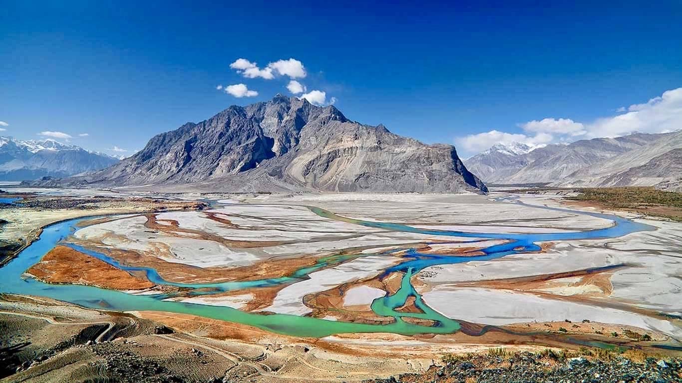
Khosar Gang is the mountain people climb first. It stands at the head of the Shigar valley, forty-five kilometres from Skardu, and almost everything about it is unusually kind for a Karakoram peak: you can be at base camp the day after you land, the approach is a walk rather than a glacier trek, and the climbing above it is steep snow and fixed rope rather than anything that needs a rack. It is the peak Pakistani guides send people up before they go anywhere near Spantik or Broad Peak.
None of which makes it small. Base camp sits at 3,800 metres, higher than anything in the Alps you can drive to, and the summit morning is a 02:30 start on crampons with a bergschrund to cross at 5,750 metres. Denis Urubko made the first winter ascent in February 2022. Two months later a three-man team went for the first spring ascent and turned round on avalanche risk without reaching the top. It is a beginner's 6,000er, not a walk-up.
What we sell it as is seventeen days: two full acclimatisation rotations, two high camps, and two days of weather margin that we would rather hand back unused than not have. The short six- and eight-day versions of this trip exist and they work for people who arrive already acclimatised. If you are flying in from sea level, they are asking you to gain 4,000 metres in under a week, and the reason they are cheaper is that they have removed the days that make the summit likely.
Trip highlights
The shortest approach to a 6,000er
The tallest mountain in the Shigar valley, and base camp is a single day's walk from the road head at Sildi — the shortest approach to a permit peak anywhere in the Karakoram.
Two acclimatisation rotations, not one
The short versions of this trip skip them, which is most of why the short versions fail.
A real summit morning
02:30 from Camp 2, fixed rope on the headwall, the bergschrund at 5,750 metres, and K2, Broad Peak and the Gasherbrums coming up out of the dark to the east as you climb.
Two spare days built in
Weather on this peak closes in fast and clears fast, and a team with a second window summits far more often than a team with one.
Route
- 1 Start
- 2 Stop in order
- 3 Finish
- Route travelled
Loading map…
At a glance
- 17 days, Islamabad to IslamabadTwelve of them active. Two are weather margin and one is a contingency day.
- 6,040 m on a GPS6,400 m on the permit. The page explains the gap — see below.
- A first 6,000 m peakFixed rope, crampons and a bergschrund. No rock climbing, no rack.
- Maximum 12 climbersWith high-altitude porters and a climbing guide above base camp.
- Shigar valley and SildiBase camp is one day's walk from the road, not a week's trek.
- Hotels either end, tents betweenIslamabad and Skardu in hotels, twin share. Two to a tent on the mountain.
- June to AugustJuly is the settled month and the one we prefer to run.
Day by day
Day 1Arrive Islamabad
Met at Islamabad International and driven to the hotel. Nothing is asked of you today beyond arriving. If your flight lands in the morning there is time to see Faisal Mosque and the Margalla hills before dinner, and we will arrange it if you want it.
Day 2Islamabad to Skardu

The forty-five minute flight up the Indus, with Nanga Parbat off the left wing on a clear morning — one of the great short flights anywhere. It is also weather-dependent: if it cancels we drive the Karakoram Highway instead, which takes the best part of two days, and the itinerary has the margin to absorb it. Skardu sits at 2,230 metres, so tonight is the first night of acclimatisation whether it feels like it or not.
Day 3Skardu — gear check and an easy day high

The morning is a full kit check with your guide: boots tried with crampons, harness fitted, layers laid out, anything missing hired or bought in the bazaar while there is still time. The afternoon is deliberately active and deliberately gentle — Kharpocho fort above the town, or the short walk out to Upper Kachura. Moving at 2,300 metres is worth more than resting at it.
Day 4Drive to Sildi, trek to base camp — 3,800 m
An hour and a half by jeep up the Shigar valley to Sildi, the village where the climb starts, then five to six hours on foot to base camp at 3,800 metres. The path goes up through terraced fields and apricot orchards and then out onto open grass and moraine, and the mountain is in front of you for most of it. Porters carry the loads. You carry a day sack.
Day 5Base camp — acclimatisation
A day at 3,800 metres doing very little, which is the point. A short walk uphill after breakfast to tag a little height and come back down, then rest. Your guide runs the rope work in the afternoon — jumar, abseil, crampon technique, self-arrest — on a slope behind camp. Everyone does this session, including people who have done it before.
Days 6–7First rotation — Camp 1 at 4,800 m
Up to Camp 1 on steep grass giving way to rock and scree, a thousand metres of gain and four to six hours depending on the load and the day. You sleep there once, and that single night is what your body needs. Back down to base camp the next morning, which will feel dramatically easier than the way up did.
Day 8Base camp — rest
A full rest day at 3,800 metres. Eat, sleep, wash, read, let the altitude settle. The guides use it to watch the forecast and start shaping the summit window, and you will hear them talking about it over dinner.
Days 9–10Second rotation — Camp 2 above 5,400 m
Back to Camp 1, and the next day up onto the upper mountain to establish Camp 2 above 5,400 metres. This is where the ground changes: snow underfoot from here, crampons on, fixed rope on the steeper sections. Sleeping this high once before the summit push is the difference between a hard summit day and one that does not happen.
Day 11Descend to base camp
Down from Camp 2 to base camp in a single long morning. Two nights above 4,800 metres are now in your blood and the mountain is stocked. The rest of the day is doing nothing at all.
Day 12Base camp — rest and the weather call
The last full rest day, and the one on which the summit plan is fixed. Your guide takes the forecast and picks the window. Kit is packed down to what goes up and what stays. An early dinner, because tomorrow is short.
Day 13Base camp to Camp 2
Straight through Camp 1 to Camp 2 in one push, carrying light. In bed by mid-afternoon with the alarm set for two in the morning, which is not the same thing as sleeping, but lying still at 5,400 metres does most of the work.
Day 14Summit day — 6,040 m, and back to base camp
Away at 02:30 by headtorch on firm night snow, because this is snow that softens and becomes dangerous once the sun is on it. The headwall is fixed and you climb it on a jumar. The bergschrund comes at about 5,750 metres and is the one obstacle on the route that genuinely needs technique rather than fitness. Above it the angle eases onto the summit slopes, and the target is to be on top by 08:30 with K2, Broad Peak and the Gasherbrums standing up in a line to the east. Down by abseil and downclimb to Camp 2, then on to base camp. It is a long day and it ends with the best meal of the trip.
Day 15Reserve day
Held for weather, and unscheduled on purpose. If the summit went on day 14 this becomes a slow morning at base camp and an early walk out. If it did not, this is the second window — and it is the reason we sell seventeen days rather than eight.
Day 16Base camp to Sildi, drive to Skardu
Down the valley to Sildi in three to four hours and back to Skardu by jeep. A hotel room, a hot shower and a bed that is not on a slope. Dinner is somewhere in town with the crew who got you up the mountain.
Day 17Fly to Islamabad and onward
The morning flight back to Islamabad, and a day room at the hotel if your international flight is in the evening. If the Skardu flight is grounded we drive, which is why we ask you not to book an international departure for the same day.
What’s included
- Return domestic flights, Islamabad to Skardu, with road transfer held in reserve if the flight cancels
- Two nights Islamabad and three nights Skardu in hotels, twin share, breakfast included
- All camping equipment above the road head — two-person tents, mess and kitchen tents, tables, chairs and mattresses
- All meals from Skardu to Skardu, cooked by our own kitchen crew on the mountain
- Climbing guide and high-altitude porters above base camp
- Fixed rope, snow stakes and ice screws for the route
- Government of Pakistan peak permit, Restricted Area permit and liaison officer where required
- 30 kg of porterage per climber between the road head and base camp
- All road transfers, Islamabad and Skardu
- Satellite phone at base camp and solar charging for the team
- Staff wages, insurance and equipment for guides, porters and kitchen crew
Not included
- International flights to and from Islamabad
- Pakistan visa, currently around US$ 100 — see our visa guide
- Personal climbing kit: boots, crampons, harness, ice axe, sleeping bag rated to −20 °C
- Travel and rescue insurance, which must cover helicopter evacuation above 6,000 metres
- Lunch and dinner in Islamabad and Skardu, so you can eat where you like
- Summit bonus for the high-altitude porters, customary and at your discretion
- Personal expenses, tips and anything not listed above
Good to know
**How high is Khosar Gang, really?**
We say 6,040 metres. Every other operator selling this peak says 6,400, and you are entitled to know why we do not.
6,400 is the figure on the Government of Pakistan permit, and the permit is the document you climb under, so it is not a lie — it is just not a measurement. Every climber who has stood on the summit with a GPS has come back saying about 6,040. The highest contour line Google Maps draws on the mountain is 5,980. The detail that settles it for most people is the bergschrund: it sits at about 5,750 metres and it is roughly three hundred metres below the summit, not six hundred and fifty. Do the arithmetic and you get a mountain a shade over 6,000, not one approaching 6,500.
We lead with the lower number because it is the one that is true, and because a brochure figure you cannot reproduce on your own watch is worth nothing to you.
What this changes in practice is almost nothing. It is still the tallest thing in the Shigar valley, still a genuine 6,000 metre summit, still harder than it looks from Skardu. What it changes is the claim you can make afterwards, and we would rather you heard that from us than from someone in a bar in Skardu a week later.
**Is this really a first 6,000er?**
Yes, with conditions. You need to be fit enough to walk uphill for six hours carrying a day sack, on consecutive days, without it ruining you. You do not need to have climbed before — the rope work is taught at base camp and the whole route above Camp 1 is fixed. You do need to be honest with yourself about the fitness, because altitude does not negotiate and the summit day is eleven or twelve hours long.
**When to come**
June, July and August. July is the settled month and the one we prefer: the snow has consolidated, the bergschrund is at its most straightforward, and the weather windows are longer. June can still be holding winter snow high up. August is warm and the afternoon snow goes soft early, which is why the summit start is so early.
**Getting there and the Skardu flight**
The flight from Islamabad is the good way and it is cancelled often — it flies visually, not on instruments, and if the cloud is in it does not go. We hold the road as a fallback and the itinerary carries the days to absorb it. Do not book a same-day international connection at the end of the trip.
**Insurance**
Non-negotiable, and it has to cover helicopter evacuation above 6,000 metres. Standard travel policies almost never do. Read the altitude clause rather than the summary, and send us the policy number before you fly.
Questions about this trip
How high is Khosar Gang?
About 6,040 metres, which is what climbers who have summited with a GPS consistently report, and it is the figure we use. The Government of Pakistan permit lists it at 6,400 metres and that is the number every other operator quotes, because the permit is the document the climb is authorised under. The highest contour Google Maps draws on the peak is 5,980 metres, and the bergschrund on the route sits at roughly 5,750 metres — around 300 metres below the top, which supports the lower reading. It is a genuine 6,000 metre summit either way, and the tallest mountain in the Shigar valley on any of the three numbers.
Is Khosar Gang a good first 6,000 metre peak?
It is one of the best in Pakistan. The approach is a single day's walk from the road at Sildi rather than a week-long glacier trek, base camp is at 3,800 metres, and the climbing above it is steep snow on fixed rope with one bergschrund — no rock climbing and no technical gear beyond crampons, harness and axe. Rope technique is taught at base camp. What it does demand is real hillwalking fitness and a willingness to spend an eleven-hour day on your feet at altitude.
Where is Khosar Gang and how do I get there?
Khosar Gang, also spelled Koser Gunge and labelled that way on Google Maps, is the tallest mountain in the Shigar valley in Baltistan, about 45 kilometres from Skardu. You fly Islamabad to Skardu in 45 minutes, drive an hour and a half up the Shigar valley to the village of Sildi, and walk five to six hours to base camp at 3,800 metres.
When is the best time to climb Khosar Gang?
June to August, and July is the best of the three. By July the snow has consolidated, the bergschrund is at its most straightforward and weather windows are longer. June can still hold unstable winter snow on the upper mountain. In August the snow softens early in the day, which is why summit day starts at 02:30 whatever the month.
Why is this 17 days when other companies sell it in six or eight?
Because the short itineraries remove the acclimatisation. A six-day trip asks someone arriving from sea level to gain about 4,000 metres in under a week, and the usual outcome is a team that reaches Camp 2 and turns round. Seventeen days buys two full acclimatisation rotations, two nights slept high before the summit push, and two spare days for weather. The short versions work for climbers who arrive already acclimatised from another peak.
Do I need previous mountaineering experience?
No, but you need the fitness. The route is fixed above Camp 1 and your guide runs a full session at base camp on jumar, abseil, crampon work and self-arrest before anyone goes high. What cannot be taught on the trip is the ability to walk uphill for six hours on consecutive days. If you can do that comfortably at home, the technical side is learnable here.
What permits are needed for Khosar Gang?
A Government of Pakistan peak permit and, depending on the year, a Restricted Area permit and a liaison officer. We arrange all of them, and they are in the price. You need a Pakistani visa, currently around US$ 100, and a passport valid for at least six months beyond your return date.
What are the chances of reaching the summit?
Good, on a well-acclimatised team in a settled July window — this is a peak where the limiting factor is almost always weather or acclimatisation rather than difficulty. We do not publish a success rate, because the honest ones are small samples and the impressive ones are invented. What we will say is that the two spare days in this itinerary exist because a team with a second weather window summits considerably more often than a team with one.
You might also consider
Spantik Expedition 7,027 mGolden Peak by the classic southeast ridge — the most accessible 7,000 m summit in the Karakoram.From US$ 3,500
 Rakaposhi Expedition 7,788 mHunza's giant by the southwest spur — steep, committing and rarely crowded.From US$ 3,800
Masherbrum Expedition 7,821 mK1, 7,821 m — the first Karakoram peak ever surveyed, and still one of the least often climbed.From US$ 4,000
Enquire about this trip
Tell us who is travelling and roughly when. A trip planner — not a call centre — replies within three hours between 9am and 11pm Pakistan time with a day-by-day itinerary and the full price, per person, with nothing hidden underneath it.
- Every itinerary written from scratch around your dates.
- Licensed operator, running these routes since 2014.
- A full costing up front — no deposit to see one.
- +92 310 5344471
- info@elhamasia.com
- 9am – 11pm PKT, seven days a week
- Office No. 227, Rohtas Road, G-9/1, Islamabad, Pakistan