
Karakoram Highway Cycling Tour
- About 400 km ridden, 7 riding days
- Khunjerab Pass, 4,693 m
- Support jeep on every stage
- 13 days, Islamabad to Islamabad
- Karakoram Highway
- Hotels throughout, en suite
- May to September
- 13-day itinerary
About this tour
The Karakoram Highway is the ride. Everything else on this itinerary — the forts, the lake, the rest day in Karimabad — is arranged around the fact that you came to cycle a road that took twenty years to build, cost around a thousand lives, and climbs to 4,693 metres at the Chinese border, which makes it the highest paved international crossing in the world.
Thirteen days, Islamabad to Islamabad, with about 400 kilometres in the saddle spread across seven riding days. That number surprises people who expect a cycling holiday to be all distance. It is deliberate. The stages here are short because they are high: you ride from roughly 1,200 metres at Chilas to 4,693 at Khunjerab over the course of a week, and a rider who treats day four as a century ride is a rider who spends day eight in the jeep with a headache. Short days, real altitude, and a rest day at Karimabad before the top half.
The gradients are kinder than the numbers suggest. This is a trade route rather than a mountain pass in the alpine sense — the highway follows the Indus and then the Hunza river upstream, so the climbing is long and shallow rather than steep, and the surface on the Chinese-rebuilt sections is better than most roads in Europe. What makes it hard is the air. At Khunjerab you have about 60 per cent of the oxygen you had at the airport.
A support jeep runs with the group on every stage, carrying the luggage, the spares, the water and anyone who has had enough for the day. Nobody is left to grind out a stage they are not enjoying, and getting in the vehicle is not a failure — most riders use it at least once, usually on the Khunjerab day, and the ones who do not are usually the ones who have ridden at altitude before.
What you see from the saddle is the reason to do this by bike rather than by coach. Nanga Parbat at 8,126 m standing over the Indus gorge near the junction where the Himalaya, Karakoram and Hindu Kush meet. Rakaposhi at 7,788 m directly above the road at Minapin, which is one of the great roadside mountain views anywhere on earth. Attabad Lake, which did not exist before a landslide dammed the Hunza river in January 2010 and buried the highway — the road now runs behind it through a series of tunnels, and you ride through them. The Passu Cones. Baltit Fort above Karimabad. And then a border gate on a snowfield at 4,693 metres, with yaks on the road and a line of trucks waiting on the Chinese side.
Be clear-eyed about two things. This is a public highway, not a closed course: there are trucks, there are buses, and Pakistani drivers use the horn as a courtesy rather than a complaint. Our riders go in a group with the jeep behind them and a guide who knows which corners are blind, and in years of running this we have found it far less alarming than it sounds — but it is a road with traffic on it, and if that is not for you, the Baltistan mountain-bike itinerary keeps to jeep tracks instead. Second, the Karakoram Highway closes without warning. Landslides and rockfall after rain can shut it for hours or for a day, which is why day twelve is a contingency day in Islamabad and why you should not book an international flight for the evening of day eleven.
It suits keen cyclists and strong weekend riders, and it does not require a racing licence or a particular power figure — it requires being able to ride four to five hours on consecutive days and keep something in reserve for altitude. Bring your own bike if you have one you love, because hire in Islamabad is possible but the choice is thin.
Trip highlights
Riding to 4,693 metres at Khunjerab
The highest paved frontier crossing on earth, inside a national park with yaks and marmots on the verge. You ride the last of it in thin, cold air with the Chinese gate ahead — and there are few finishing lines in cycling like it.
Rakaposhi from the road at Minapin
7,788 metres standing more or less directly above the highway, with about 6,000 metres of relief from the river to the summit. Most riders stop here without being told to.
Attabad Lake and the tunnels
A mountainside came down in January 2010, dammed the Hunza river and drowned the highway for five years. You ride the replacement: a chain of tunnels behind twenty-odd kilometres of turquoise water.
A rest day in Karimabad, not a transfer day
Baltit Fort, seven centuries old and properly restored, Altit below it, and the Duikar ridge for anyone whose legs still want a climb. Placed before the high half of the ride because that is where the recovery does most good.
Short stages, so you can actually ride them
32 km on the day into Karimabad, 41 to Sost. Operators selling 100 km days on the KKH are selling you a jeep ride with a bike on the roof, because that is how those days end above 3,000 metres.
A jeep behind you all the way
Luggage, spare wheels, tools, water and a mechanic's toolkit travel in it, and so does anyone who wants to. Using it is normal — most riders do on at least one stage, and nobody keeps score.
Route
- 1 Start
- 2 Stop in order
- 8 Finish
- Route travelled
Loading map…
At a glance
- About 400 km ridden, 7 riding daysShort stages on purpose: the difficulty here is altitude and consecutive days, not distance.
- Khunjerab Pass, 4,693 mThe highest paved international border crossing in the world, and the top of the ride.
- Support jeep on every stageLuggage, spares, water and a seat for anyone who has had enough that day.
- 13 days, Islamabad to IslamabadIncluding a rest day at Karimabad and a contingency day for the highway closing.
- Karakoram HighwayChilas to the Chinese border, up the Indus and then the Hunza river past Rakaposhi and the Passu Cones.
- Hotels throughout, en suiteThree and four star, twin share, with single rooms on request. No camping on this itinerary.
- May to SeptemberKhunjerab is a summer road. June and September balance an open pass against valley heat.
Day by day
Day 1Arrive Islamabad — bike build and briefing

Met at the airport and driven to the hotel. The afternoon is for building bikes, checking them over and sorting anything that did not survive the flight — we have a mechanic's toolkit and a track pump, and the bike shops of Islamabad are twenty minutes away if something is properly broken. The briefing covers the road, the traffic, the altitude profile and how the support jeep works. If you land early there is time for the Faisal Mosque and the Margalla foothills before dinner.
Day 2Drive Islamabad to Chilas — 461 km on the Karakoram Highway
A long transfer day and the only one, eight to nine hours north through Taxila, Hassan Abdal and Mansehra, then onto the Karakoram Highway proper and up the Indus gorge to Chilas at around 1,250 metres. The bikes travel on the roof. It is worth watching rather than sleeping through: you pass the junction where the Himalaya, Karakoram and Hindu Kush meet, and the viewpoint for Nanga Parbat at 8,126 m, which is the ninth highest mountain on earth and stands entirely clear of anything else.
Day 3First ride — Chilas towards Gilgit, 128 km with the jeep in support

The first day on the bike and the longest on paper: 128 kilometres of the Karakoram Highway between Chilas and Gilgit, ridden in sections with the jeep leapfrogging ahead so the group can split the distance according to how everyone feels on their first day at altitude. The gorge here is enormous and almost bare — grey walls, the Indus grey below them, and very little green until the Gilgit river valley opens out. Hot work in the middle of the day, which is why we start early. Night in Gilgit at about 1,500 metres.
Day 4Gilgit to Minapin — 80 km, and Rakaposhi above the road
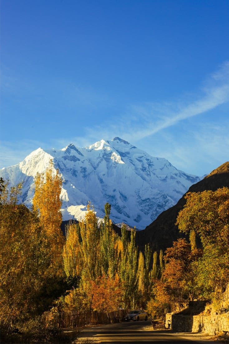
Eighty kilometres up the Hunza river with around 1,350 metres of climbing and a fast descent in the middle, finishing at Minapin at roughly 2,030 metres. This is the day Rakaposhi arrives: 7,788 metres, standing above the highway with the summit visible from the saddle, and the roadside viewpoint where every vehicle in Pakistan stops for tea. The riding is steady rather than steep — trade-route gradients, the road climbing with the river — and it is the first stage where the altitude is doing something to your legs.
Day 5Minapin to Karimabad — a short 32 km into Hunza

Thirty-two kilometres and about 700 metres of climbing into Karimabad at roughly 2,400 metres. A deliberately short stage: it puts you into Hunza by lunchtime with the afternoon free, and it is the last easy day before the road goes properly high. The ride crosses the Hunza river and climbs the terrace to Karimabad, with Rakaposhi behind you and the Ultar wall ahead. Two nights here.
Day 6Rest day in Karimabad — Baltit Fort, Altit and Duikar

Off the bike, and placed here on purpose: recovery before the high half of the ride does more than recovery after it. Baltit Fort stands at the top of the village, around seven centuries old and pulled back from collapse by a restoration that is studied internationally; Altit is older still, with a royal garden below it. Anyone whose legs are still willing can ride or walk up to the Eagle's Nest at Duikar, about 2,850 metres, which is a proper climb and an optional one. Everyone else drinks apricot juice and looks at the mountains.
Day 7Karimabad to Sost — 41 km past Attabad and the Passu Cones

Forty-one kilometres and the most photographed stretch of the whole highway. Out of Karimabad and down to Attabad Lake, where a landslide dammed the Hunza river in January 2010, drowned four villages and cut the road for five years — you ride the replacement alignment, a chain of tunnels behind twenty kilometres of turquoise water. Beyond it the Passu Cones stand over the road, a serrated ridge that looks unreal in photographs and worse in person. Night at Sost, the last town before the border, with customs sheds and truck parks and a very different feel from Hunza.
Day 8The Khunjerab Pass — 4,693 m, and down to Gulmit

The day you came for. From Sost the road climbs into Khunjerab National Park, where yaks, marmots and sometimes ibex are on the verge, and keeps climbing until the valley opens into a broad snowfield with the Chinese border gate at the top of it at 4,693 metres. About 80 kilometres of the day is ridden and the rest is driven; the split is decided on the morning by how the group is going, because at this altitude the honest plan is the one made on the day. Cold at the top whatever the calendar says, and windy. Then the descent, which is long, fast and the best hour of the trip, down to Gulmit for the night.
Day 9Gulmit to Minapin — 68 km, and 1,450 metres of descent

Sixty-eight kilometres back down the valley with far more descending than climbing — about 1,450 metres down against 680 up — which after the pass feels like being paid back. The same road looks completely different ridden the other way, with the light on the opposite walls and the Passu ridge behind you rather than ahead. Night at Minapin, under Rakaposhi again.
Day 10Minapin to Gilgit — 80 km, and the last of the riding

The final stage: 80 kilometres back down the Hunza river to Gilgit, mostly downhill, finishing in the early afternoon. Anyone who would rather walk than ride can take the morning up towards the Minapin glacier and the Rakaposhi base camp meadow instead, with the jeep bringing them down to meet the group. Gilgit in the afternoon, bikes cleaned and packed, and the last dinner in the mountains.
Day 11Fly Gilgit to Islamabad

The morning flight south is an hour of low flying through the Indus gorge with Nanga Parbat off the left wing, and it is the best value scheduled flight in Pakistan. It is also entirely weather-dependent and cancels often, which is exactly what tomorrow is held for: if it does not go, we drive, and the drive is a long day. Boxed bikes travel as sports baggage on the flight, and in the jeep if we drive.
Day 12Contingency day in Islamabad

Held in reserve, and used often enough that we will not sell this trip without it — it absorbs a cancelled Gilgit flight or a highway closure without costing anyone their flight home. If it is not needed, it is a free day in Islamabad: the Faisal Mosque, the Pakistan Monument, the lanes and restaurants of Saidpur village, the Margalla ridge, or a long lunch and nothing else. Bikes get boxed properly this afternoon rather than at midnight.
Day 13Departure from Islamabad

Breakfast and a transfer to the airport with the bikes. Most international departures from Islamabad leave late in the evening, so a day room can be held if your flight is a night one, and extra nights or an onward extension are easy to arrange — Lahore is two hours south and worth a couple of days on its own.
What’s included
- Twelve nights in hotels, three and four star, twin share and en suite
- All meals from arrival in Islamabad to departure — full board throughout
- A support jeep with driver on every riding stage, carrying luggage, water, spares and riders
- An English-speaking guide and a tour manager with the group for the whole trip
- Return domestic flight Gilgit to Islamabad, with the Karakoram Highway drive held as the weather alternative
- All road transport, including the drive north and the transfer days
- Khunjerab National Park fees, site entry fees and the permits the route requires
- All airport transfers, international and domestic
- A contingency day in Islamabad, built into the itinerary rather than charged as an extra
Not included
- International flights to and from Pakistan, and the Pakistan visa
- Travel insurance, which must cover cycling and altitude to 5,000 m
- Bicycle hire — possible in Islamabad, with a limited choice, and quoted separately
- Your own helmet, pedals, shoes, saddle and clothing, which we strongly recommend bringing
- Spare parts specific to your bike, particularly a rear derailleur hanger and tubes in your size
- Single room supplement
- Tips, drinks, laundry and anything personal
Good to know
How hard is it, really
Around 400 kilometres over seven riding days, on sealed road, with a support vehicle. On gradient alone it is well within a strong weekend rider's range: the Karakoram Highway is a trade route, so it climbs long and shallow beside the rivers rather than in alpine ramps.
What makes it challenging is everything else. You ride on consecutive days, you sleep progressively higher, and the last stage tops out at 4,693 metres where there is roughly 60 per cent of the oxygen you started with. Heat in the Indus gorge can pass 40 °C in July while the pass is near freezing. If you can ride four or five hours back to back and still enjoy the fifth day, you will be fine here — and if you cannot, the jeep is not a penalty box.
Bring your own bike if you possibly can
Hire exists in Islamabad and the choice is thin — a handful of hardtails, not a fitted road bike. Most riders bring their own, and it is worth the airline fee to be on a bike that fits you for seven days at altitude.
What to bring with it: spare tubes in your size, a spare derailleur hanger for your frame (this is the part nobody carries and the part that ends trips), brake pads, a chain link, and your own pedals, saddle, shoes and helmet whatever else you hire. Tyres of 28 mm or wider are more comfortable than anything narrower, gravel tyres are ideal, and a low bottom gear matters more than a fast top one. We carry a track pump, a full toolkit and spares for common standards, and there are competent mechanics in Gilgit and Karimabad — but not for anything proprietary.
What the support jeep actually does
It runs with the group on every stage. It carries the luggage, the water, the spares and the food, it marks the group on the road for traffic behind, and it carries riders. Getting in is ordinary — most people do it at least once, usually somewhere above 4,000 metres on the Khunjerab day — and nobody on our staff keeps a tally. The alternative, which some operators run, is a rider alone on a highway at altitude with a mechanical and no phone signal, and we are not willing to sell that.
Traffic, and what the road is like
This is a working public highway, not a closed course. There are trucks, buses and Hiace vans, and the Pakistani horn means "I am here" rather than "get out of the way". The surface on the Chinese-rebuilt sections is excellent — better than most European roads — and rougher in patches between Chilas and Gilgit. We ride in a group with the jeep behind, start early when the road is quiet, and a guide who knows the blind corners rides with you. Riders are consistently surprised by how much calmer it is than they expected. Take a rear light and wear something bright anyway.
The highway closes sometimes
Landslides and rockfall after rain can shut the Karakoram Highway for a few hours or a day, and the Gilgit flight cancels in poor weather. That is why day twelve is a contingency day and why we ask you not to book an onward international flight for the evening of day eleven. Neither is a remote possibility; both are a normal part of a Karakoram summer.
Altitude, and how the itinerary handles it
The profile is built to acclimatise you: Chilas at about 1,250 m, Gilgit 1,500, Minapin 2,030, Karimabad 2,400 with a rest day, Sost higher again, and only then the ride to 4,693 m — which you go up and come back down from the same day rather than sleeping high. Expect to feel it above 4,000 m: shortness of breath, a headache, legs that produce noticeably less. That is normal. What is not normal is worsening headache, nausea or unsteadiness, and the guide's call to put someone in the jeep is final.
The border, and what you can and cannot do at it
Khunjerab is the highest paved international crossing in the world and you can ride to the gate, photograph the marker and stand with a foot in each country. You cannot cross: that needs a Chinese visa arranged well in advance and a different itinerary. The pass sits inside Khunjerab National Park and the entry fee is included. Carry your passport on that day — it is checked at Sost.
Season, and which months to choose
May to September. Khunjerab is a summer road and the top is snowbound outside that window. June and September are the best compromise: the pass is reliably open and the Indus gorge is not yet, or no longer, at its worst. July and August are hotter in the low sections and bring more rain, which is when the highway is most likely to be blocked. Private groups can pick their own dates inside the season.
Where you sleep, and what the food is like
Hotels every night, three and four star by local standards, twin share and en suite, with single rooms on request. No camping on this itinerary. Full board is included and the food is better than most riders expect — Hunza in particular does very good vegetarian food, apricots in everything, and enough carbohydrate to ride on. Tell us about dietary requirements two weeks out and they are straightforward to meet.
Questions about this trip
How much does the Karakoram Highway cycling tour cost?
It is quoted per person against your dates and group size rather than published here. What moves the figure: how many of you there are, since the support jeep, the guide and the tour manager cost the same for four riders as for ten; whether you want single rooms; whether you need bikes hired in Islamabad; and the season, with July and August pricing higher than the shoulder months. What the quotation always covers is the same list — twelve nights, all meals, the support vehicle on every stage, the guide, the Gilgit flight, park fees and all transfers. Send us your dates and numbers and you get an itemised price.
How fit do I need to be?
Fit enough to ride four to five hours on consecutive days and still want to ride the next one. You do not need racing form or a power figure: the stages are short by cycling-holiday standards, between 32 and 128 km, and the gradients are shallow because the highway follows the rivers. What catches people is the combination of back-to-back days and altitude. The single best preparation is a few weekends of consecutive long rides rather than one heroic day, and if you already ride 80 km on a Sunday without ceremony you are in good shape for this.
Should I bring my own bike or hire one in Pakistan?
Bring your own if you have one. Hire is available in Islamabad but the choice is limited — a few hardtail mountain bikes rather than a fitted road or gravel bike — and seven days at altitude on a bike that does not fit you is a long week. If you do bring your own, pack a spare derailleur hanger for your frame, tubes in your size, brake pads and a chain link. Whatever you decide about the bike, bring your own helmet, pedals, shoes and saddle.
What kind of bike is best for the Karakoram Highway?
A gravel bike or an endurance road bike with tyres of 32 mm or wider is the sweet spot: the surface is sealed for almost the whole route and genuinely good on the rebuilt sections, but there are rough patches, and comfort matters more than speed over seven days. A hardtail mountain bike works perfectly well and is what most hire bikes are. What matters more than the frame is the gearing — take a lower bottom gear than you think you need, because riding at 4,000 metres turns an easy gradient into a hard one.
How high is the Khunjerab Pass, and do we cycle all of it?
4,693 metres, the highest paved international border crossing in the world. Roughly 80 kilometres of that day is ridden and the rest is driven, and the split is decided on the morning according to how the group is going — which is the honest way to plan a day at that altitude. Everyone who wants to ride the final section to the gate gets to ride it. Then the descent, which is long, fast and the single best hour of the trip.
Is there a support vehicle, and is it an admission of defeat to use it?
There is a jeep on every stage and no, it is not. It carries the luggage, the water, the spares and the food, it sits behind the group for visibility in traffic, and it carries riders whenever they want to be carried. Most people use it at least once — usually somewhere above 4,000 metres — and nobody on our staff counts. The point of the vehicle is that nobody is ever alone on a highway at altitude with a mechanical, which is the actual risk on a trip like this.
Is it safe to cycle on the Karakoram Highway?
It is a working public highway with trucks and buses on it, and that deserves a straight answer rather than reassurance. The mitigations are real: we ride as a group with the support jeep behind, start early when the road is quiet, and a guide who knows the route rides with you. The surface on the Chinese-rebuilt sections is excellent. Pakistani drivers use the horn to announce themselves rather than to complain, which is disconcerting for a day and then normal. Most riders finish the trip saying it was calmer than they expected. If riding in any traffic is the part you cannot accept, look at the Baltistan mountain-bike itinerary, which stays on jeep tracks.
When is the best time of year for this ride?
June and September. Khunjerab is a summer road, open roughly May to September, and those two months give you an open pass without the worst of the valley heat — the Indus gorge below Gilgit can pass 40 °C in midsummer. July and August are hotter and wetter, and rain is what closes the highway. May can still have snow at the top. Private groups choose their own dates within the season.
What happens if the highway is blocked or the flight is cancelled?
Both happen, so the itinerary is built for them. A landslide typically closes the road for hours rather than days and we wait it out or reroute the stage. The Gilgit flight is weather-dependent and cancels regularly, in which case we drive, and the drive takes a long day. Day twelve exists for exactly this, which is why we will not sell a shortened version without it. The practical rule: do not book your international flight for the evening of day eleven.
How much climbing is there each day?
Modest by alpine standards. The biggest single day is Gilgit to Minapin at around 1,350 metres of ascent over 80 kilometres, and most days are well under that — the Karimabad stage is about 700 metres in 32 kilometres. The Khunjerab day is the exception and it is ridden partly by jeep. The profile is a net climb from roughly 1,250 metres at Chilas to 4,693 at the border, spread over a week, which is what makes it an altitude ride rather than a climbing one.
Can I cross into China at the top?
Not on this trip. You can ride to the gate, photograph the marker stone and stand on the line, but crossing requires a Chinese visa obtained well in advance, and the onward journey to Tashkurgan and Kashgar is a different itinerary with its own paperwork. If that is what you want, tell us at the enquiry stage rather than at Sost — it is arrangeable, it is not arrangeable in a week.
Where do we sleep, and are there camping nights?
Hotels every night, twelve of them, three and four star by local standards, twin share and en suite, with single rooms on a supplement. No camping on this itinerary. Standards vary honestly with the geography — comfortable in Islamabad, Gilgit and Karimabad, simpler at Sost and Chilas where the choice is limited. Full board is included, and bikes are stored securely indoors every night, not left on a roof rack in the car park.
Can we ride it as a private group, or on our own dates?
Yes, and most departures are private groups — a club, a few friends, sometimes one couple. Private groups pick their own dates inside the May to September window and can adjust the stages: more riding on the transfer day, a longer rest at Karimabad, an extra night at Gulmit to ride the Shimshal road. Tell us what you want the ride to be and we will build the profile around it rather than the other way round.
Do I need a permit to cycle the Karakoram Highway?
No special cycling permit for the standard route, and no NOC for the valleys this trip rides through. Khunjerab National Park charges an entry fee, which is included. You will need a Pakistan visa, which most nationalities now obtain online, and we issue the supporting invitation letter. Carry your passport on riding days: there are checkposts along the highway that record foreign nationals, and one at Sost before the pass.
Enquire about this trip
Tell us who is travelling and roughly when. A trip planner — not a call centre — replies within three hours between 9am and 11pm Pakistan time with a day-by-day itinerary and the full price, per person, with nothing hidden underneath it.
- Every itinerary written from scratch around your dates.
- Licensed operator, running these routes since 2014.
- A full costing up front — no deposit to see one.
- +92 310 5344471
- info@elhamasia.com
- 9am – 11pm PKT, seven days a week
- Office No. 227, Rohtas Road, G-9/1, Islamabad, Pakistan