Pamir Highway & Fann Mountains Trek
- 12 days, Dushanbe to Osh
- Max altitude 4,655 m (Ak-Baital Pass)
- Best season June to September
- 4 to 12 travellers
- Tajikistan and Kyrgyzstan
- Mostly 4x4, with walking days
- 12-day itinerary
About this tour
The Pamir Highway is the second-highest international road in the world and the main reason people come to Tajikistan. This trip drives it from end to end, from Dushanbe down the Panj river to Khorog, through the Wakhan Valley, across the high plateau to Murghab and Karakul, and over the Kyzyl-Art pass into Kyrgyzstan to finish in Osh. Before that, it spends three days at the Seven Lakes of Haftkul on the western edge of the Fann Mountains.
We want to be plain about the balance, because the title says trek. This is an overland journey with walking in it, not a trekking holiday. Two days are spent on foot at Haftkul: one full day walking up the chain of lakes to the seventh, Hazorchashma, and back, and shorter walks either side. The rest is 4x4 travel, and several of those days are eight to ten hours on roads that are broken, unpaved or both. A true Fann Mountains trek, over a pass to the Alauddin or Kulikalon lakes, needs three or four days more than this itinerary has; we are happy to build one, but this is not it.
The road is the experience. For two days from Kalaikhum to Khorog and on into the Wakhan, it runs beside the Panj with Afghanistan on the far bank, close enough to see villages, fields and people walking on the other side. In the Wakhan the Hindu Kush rises above the Afghan shore, and there are fortress ruins and hot springs on the Tajik side. Then the road climbs out of the valley over the Khargush pass onto the Pamir plateau at around 4,000 metres, a cold, open landscape of grazing land and Kyrgyz herding families.
The last days are the highest. A night in a yurt with a herding family near Murghab, the Ak-Baital pass at 4,655 metres, a night beside Karakul lake at about 3,900 metres, and the long descent over Kyzyl-Art into the Alay valley and down to Osh.
The Gorno-Badakhshan region needs a permit, the Tajik–Kyrgyz border at Kyzyl-Art has a history of closures, and the altitude on the plateau is real. All three are covered in Good to know, and the first two need confirming before each departure.
Trip highlights
Fann Mountains and the Seven Lakes (Haftkul)
A chain of seven lakes in the Shing valley on the western edge of the Fann range, coloured from green to turquoise. A rough road runs up past the first six; you walk from the sixth, Marguzor, to the seventh, Hazorchashma, and back, about five hours. These are day walks from village homestays, not a camping trek.
The M41 Pamir Highway by 4x4
Dushanbe to Osh, about 1,300 km by the Wakhan route and some 2,000 km of driving on the trip as a whole, from the cotton fields of the south to a plateau at 4,000 metres. Parts are good asphalt, parts are potholed, and parts are gravel. Several days are eight to ten hours on the road.
Views across the Wakhan Valley
From the Tajik bank of the Panj you look across into Afghanistan's Wakhan, with the Hindu Kush above it. The Tajik side has the Yamchun fortress, the hot springs at Bibi Fatima, the Buddhist stupa at Vrang and the petroglyphs above Langar.
Karakul alpine lake
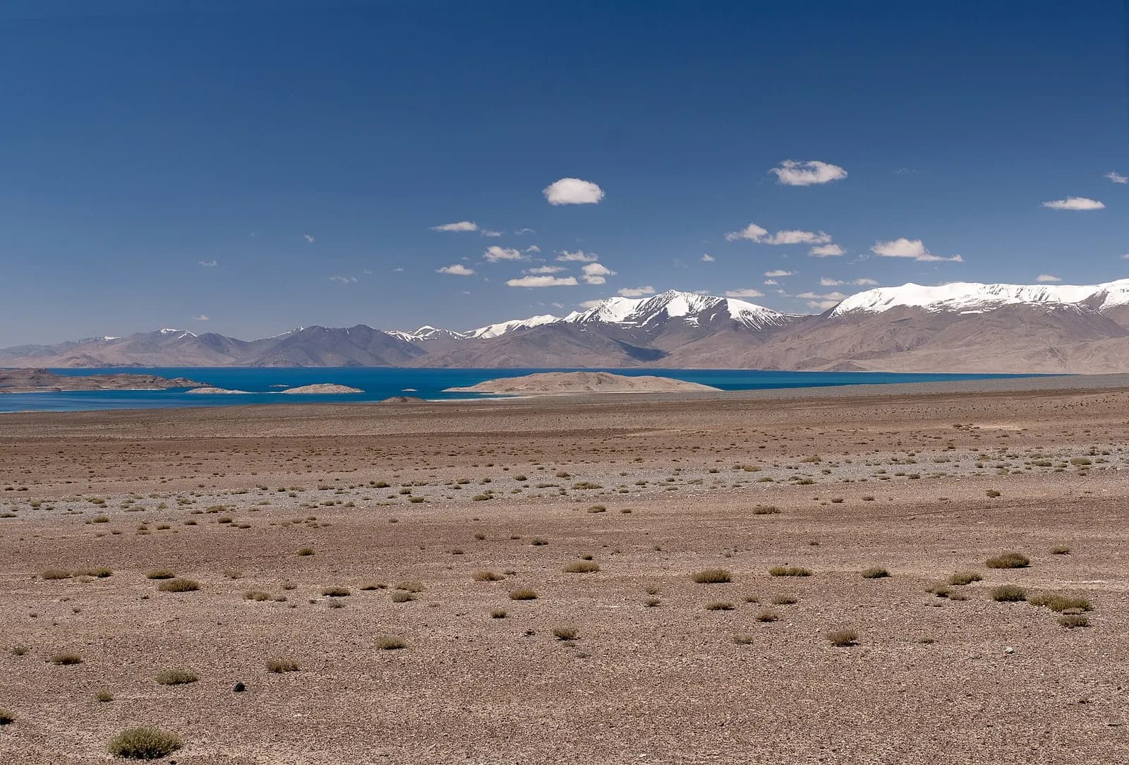
A large, salty lake at about 3,900 metres in a basin thought to be an impact crater, with snow peaks on all sides and a small Kyrgyz village on its eastern shore where you spend the night. The highest night of the trip.
Nomadic yurt stay near Murghab
A night with a Kyrgyz herding family in their summer yurt camp in a side valley near Murghab. Where exactly depends on where the family is grazing that summer. Felt walls, sleeping on the floor on thick mats, and very cold nights.
Route
- 1 Start
- 2 Stop in order
- 13 Finish
- Route travelled
Loading map…
At a glance
- 12 days, Dushanbe to OshTwo walking days at Haftkul, then seven days on the road through the Pamirs.
- Max altitude 4,655 m (Ak-Baital Pass)Crossed by road. Highest night is at Karakul, about 3,900 m.
- Best season June to SeptemberThe high plateau is cold even in August; outside these months, snow on the passes.
- 4 to 12 travellersThree or four travellers to each 4x4, with its own driver.
- Tajikistan and KyrgyzstanHaftkul, the Panj valley, Khorog, the Wakhan, Murghab and Karakul, ending in Osh.
- Mostly 4x4, with walking daysSeveral days of eight to ten hours on rough roads. This is an overland trip first.
Day by day
Day 1Arrive Dushanbe, 800 m
Met at the airport and taken to the hotel. A briefing with the guide in the evening on the road ahead, the kit list and the permits, and a first walk along Rudaki Avenue if you arrive in time.
Day 2Dushanbe to Haftkul (Seven Lakes), about 2,100 m
North through the Anzob tunnel to the Zeravshan valley, west to Penjikent, then south up the rough Shing valley road past the first lakes. About 300 km and seven hours. Homestay in a village by Marguzor lake, the sixth of the seven, with a short walk along the shore before dinner.
Day 3Walk to Hazorchashma, the seventh lake

The main walking day: from Marguzor up the valley on a mule path to Hazorchashma at about 2,400 metres and back, roughly five hours with 300 to 400 metres of climbing. Optional extra hours higher up the valley for the strong. Second night at the homestay.
Day 4Haftkul to Dushanbe
A morning walk among the lower lakes, then the same road back to Dushanbe, about seven hours. A night in a proper hotel, and the last reliable hot shower and fast internet for a week.
Day 5Dushanbe to Kalaikhum, 1,200 m
The first long 4x4 day: about 360 km by the southern route through Kulob, nine to ten hours. In the afternoon the road meets the Panj river and follows it, with Afghanistan on the far bank. The GBAO permit is checked at the first checkpoint. Guesthouse in Kalaikhum.
Day 6Kalaikhum to Khorog, 2,100 m
About 240 km along the Panj, seven to eight hours on a road that is narrow, unpaved in places and cut into the valley wall. Afghan villages and the track on the other side are often a stone's throw away. Guesthouse in Khorog, the regional capital of Gorno-Badakhshan.
Day 7Into the Wakhan Valley to Langar, 2,800 m
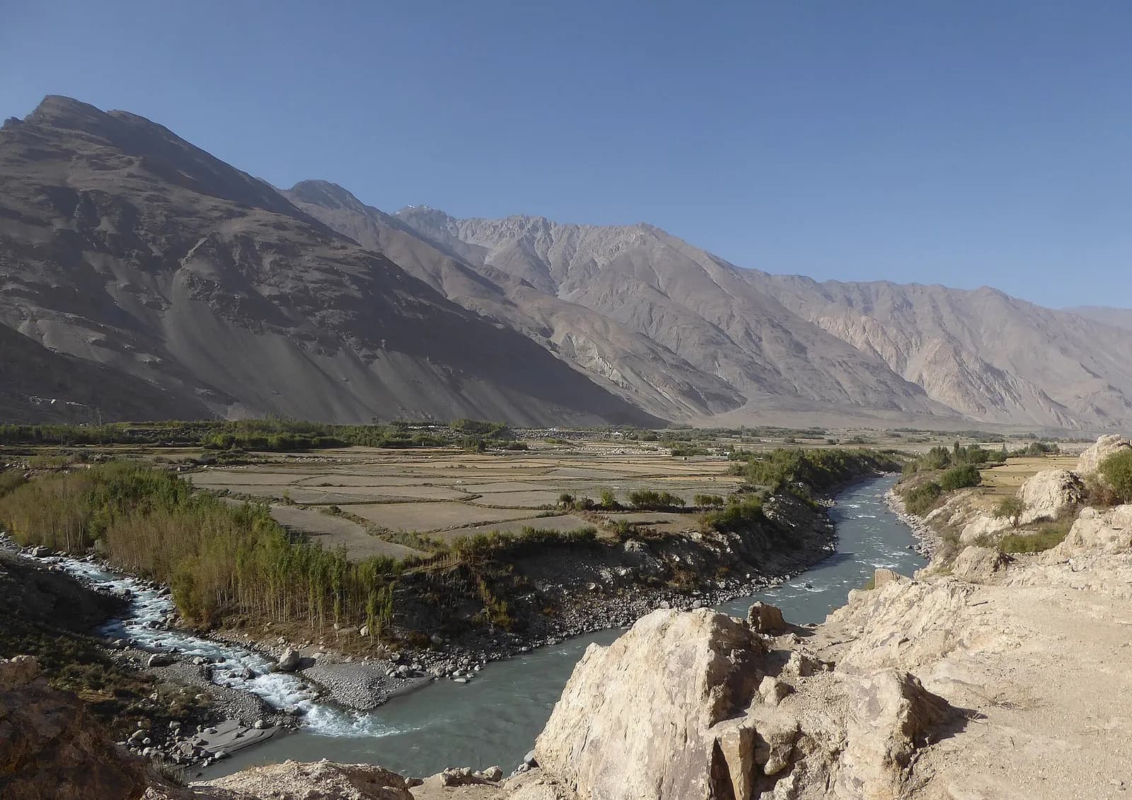
South to Ishkashim and east into the Wakhan, with the Hindu Kush rising on the Afghan side. Stops at the Yamchun fortress and the Bibi Fatima hot springs above it, and the stupa at Vrang. About 220 km and eight to nine hours with the stops. Homestay at Langar, with a short walk to the petroglyphs above the village in the evening if there is light.
Day 8Over the Khargush pass to Murghab, 3,600 m
The road climbs out of the Wakhan over the Khargush pass at about 4,340 metres onto the Pamir plateau, past the lakes and grazing land around Alichur, and joins the M41 to Murghab. About 230 km and eight hours. The first night at real altitude, in a Murghab guesthouse.
Day 9Yurt stay with a herding family near Murghab, about 3,800 m
A short drive into a side valley to a Kyrgyz herding family's summer camp. The day is deliberately easy: a walk on the grazing land around the camp, the milking and the evening return of the animals, and time to let the body catch up with the altitude. Night in a yurt, on the floor, and cold.
Day 10Over the Ak-Baital Pass, 4,655 m, to Karakul, about 3,900 m
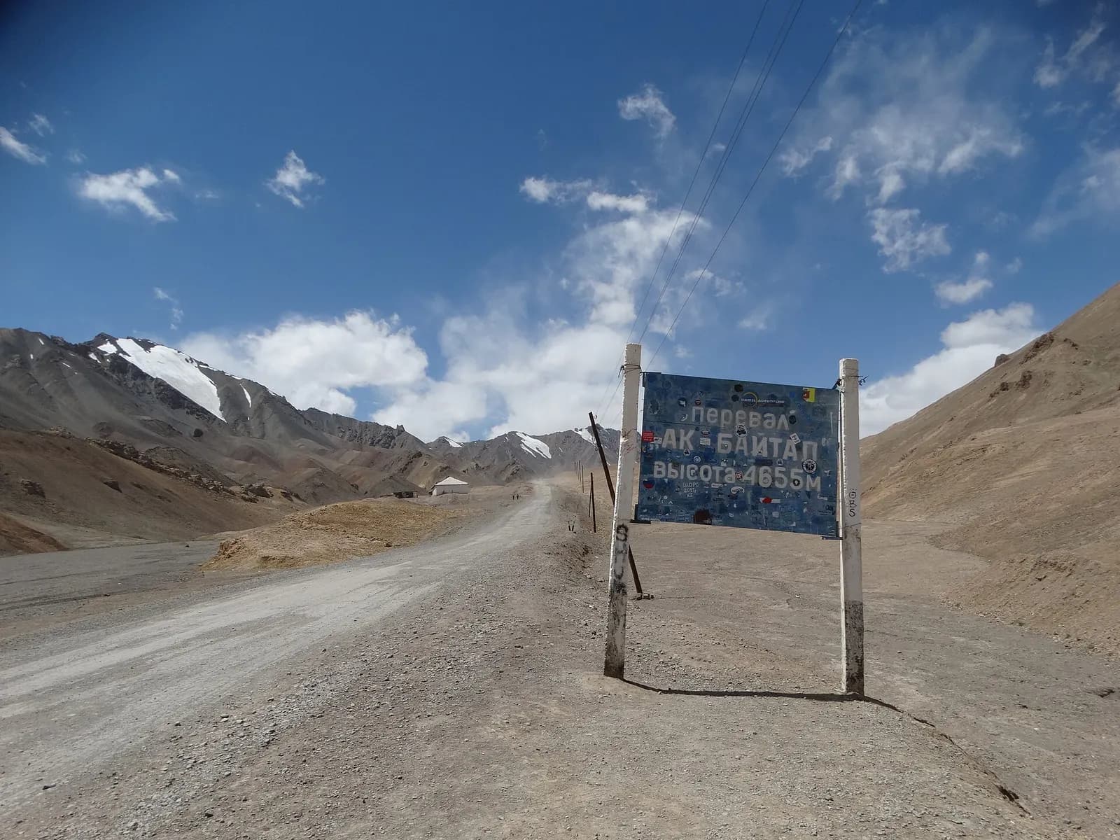
North on the M41 alongside the Chinese border fence to the Ak-Baital Pass, the highest point of the highway and of the trip, then down to Karakul lake. About 130 km and four hours, which leaves the afternoon for a walk on the lakeshore. Homestay in Karakul village, the highest night of the trip.
Day 11Over the Kyzyl-Art Pass to Osh, Kyrgyzstan, 1,000 m
Over the Kyzyl-Art pass at about 4,280 metres and through the Tajik and Kyrgyz border posts, which are some distance apart across no-man's-land. Down into the Alay valley at Sary-Tash, with the Pamir peaks behind, and on to Osh. About 260 km and eight to nine hours including the border. Hotel in Osh, and a farewell dinner.
Day 12Depart Osh
Transfer to Osh airport for your onward flight; there are daily connections to Bishkek and onward routes to Moscow and Istanbul. With a spare morning, climb Sulaiman-Too, the rock in the middle of the city.
What’s included
- Two nights in a Dushanbe hotel and one in Osh, twin share
- Eight nights in guesthouses, village homestays and one yurt, often in shared rooms with shared or outdoor toilets
- All meals from lunch on day 2 to lunch on day 11, except dinner in Dushanbe on day 4; breakfast in Dushanbe and Osh
- An English-speaking guide from Dushanbe to Osh
- 4x4 vehicles with experienced Pamir drivers, three or four travellers to each, and all fuel
- CONFIRM — Gorno-Badakhshan (GBAO) permit, applied for with your Tajik e-visa
- CONFIRM — Entry fees for the sites on the itinerary
- Airport transfers in Dushanbe and Osh, and drinking water in the vehicles
Not included
- International flights into Dushanbe and out of Osh
- Visa fees: the Tajik e-visa, and a Kyrgyz visa if your passport needs one
- Travel insurance, which must cover overland travel to 4,700 m and evacuation, and is not optional
- Lunch and dinner in Dushanbe and Osh
- Drinks, hot-spring entry, banya in homestays and personal spending
- Tips for the guide, drivers and host families
- Single supplement, where single rooms exist at all
- Costs arising from a closed border, a landslide, a road closure or an early descent
Good to know
What this trip is, honestly
An overland journey with walking at the start. The Haftkul days are day walks from a homestay, on mule paths, with one full day of about five hours. From day 5 onwards you are in a 4x4 for most of every day, and five of those days are eight hours or more on roads that are rough, narrow and dusty. If you want a Fann Mountains trek with camping and passes, we can build one; this trip is for people who want the Pamir Highway and some walking, not a trekking holiday.
Visas, the GBAO permit and the Kyrgyz border
Tajikistan issues e-visas online, and the Gorno-Badakhshan Autonomous Region (GBAO), which covers Khorog, the Wakhan, Murghab and Karakul, needs a separate permit, applied for alongside the e-visa. Your permit is checked at several roadside posts, so carry the printed copy. Kyrgyzstan is visa-free for many nationalities; check yours.
The region has a history of being closed to visitors at short notice, most recently during unrest around Khorog in 2022, and the Tajik–Kyrgyz border was closed for long periods after the conflict of 2021–2022. We confirm the permit position and that the Kyzyl-Art crossing is open to foreigners before every departure. If it is not, the trip is rerouted to finish back in Dushanbe, which adds days and cost.
Safety and the Afghan border
For two and a half days the road follows the Panj with Afghanistan on the far bank. The Tajik side is calm and the route is driven by tourists every summer, but several governments advise caution or advise against travel close to the Afghan border, and that advice can affect your insurance. Check your own government's travel advice and your policy wording before booking. The everyday hazards are the road itself — rockfall, washed-out sections, river crossings after rain — and the altitude.
Altitude
You sleep at about 3,600 metres in Murghab, 3,800 at the yurt and 3,900 at Karakul, and cross passes at 4,340, 4,655 and 4,280 metres. The ascent is gradual and the yurt day is there to help, but headaches, broken sleep and breathlessness are normal on the plateau. Persistent vomiting, confusion or loss of coordination are not, and the response is to go down — which on the plateau means driving, sometimes for hours. Talk to your doctor about Diamox before you travel.
Season, weather and what to bring
June to September. Dushanbe can reach 40 °C in July while Karakul drops below freezing at night in August. Bring layers for both, a down jacket, a warm hat, and a sleeping bag liner; a sleeping bag rated to about minus five makes the yurt night much more comfortable. Sun at 4,000 metres burns in minutes, so bring high-factor sunscreen and good sunglasses.
Homestays, money and connectivity
Outside Dushanbe and Osh you stay in family guesthouses and homestays: shared rooms on mats or simple beds, shared or outdoor toilets, a banya (a wood-fired wash-house) rather than a shower in many places, and electricity that can be intermittent. Meals are simple — soup, bread, rice, potatoes, yoghurt. Carry Tajik somoni in cash, plus clean US dollars in reserve; there are ATMs in Dushanbe and Khorog and almost nowhere else. Mobile signal is patchy after Khorog and absent at the yurt and much of the plateau.
Questions about this trip
How hard is the Pamir Highway and Fann Mountains trip?
The walking is moderate: two days of day walks at Haftkul, the longest about five hours with a few hundred metres of climbing. What makes it challenging is the rest — long days on rough roads, several of eight to ten hours, basic homestays, and four nights between 3,600 and 3,900 metres. It suits people who are reasonably fit, comfortable with basic accommodation, and patient in a vehicle.
Is this really a trek?
Only partly, and we would rather say so now. It is an overland trip by 4x4 with two walking days at the Seven Lakes. A full Fann Mountains trek over a pass to the Alauddin or Kulikalon lakes needs three or four extra days, and we can add one if that is what you want.
Do I need a permit for the Pamir Highway?
Yes. Gorno-Badakhshan, the region that includes Khorog, the Wakhan, Murghab and Karakul, needs a GBAO permit on top of the Tajik e-visa. It is applied for with the e-visa and checked at roadside posts. We arrange it and confirm its status before every departure, because the region has occasionally been closed to visitors at short notice.
How bad is the altitude?
Real but manageable for most people. The highest point is the Ak-Baital Pass at 4,655 metres, crossed by road, and the highest night is at Karakul at about 3,900 metres. The itinerary climbs gradually through Khorog and Langar and includes an easy day at the yurt near Murghab. Mild headaches and poor sleep are common on the plateau; anything worse means going down.
Is it safe so close to Afghanistan?
The Tajik bank of the Panj is calm, and tourists drive this road every summer. That said, some governments advise caution or against travel near the Afghan border, and that can affect insurance, so check your own government's advice and your policy wording. The more common hazards are rockfall, washed-out road and altitude.
When is the best time to drive the Pamir Highway?
June to September. Earlier and later, snow can close the high passes and the Haftkul road, and the plateau is bitterly cold. July and August are the most reliable months for the road; June has more snow on the peaks and more meltwater in the rivers, September has clear air and cold nights.
Can I join as a single traveller or book privately?
Yes to both. Single travellers share rooms where rooms exist; in homestays and the yurt, sleeping is often in a shared room regardless. The trip also runs privately for small groups on your own dates. For an easier introduction to the region, see our Five Stans Silk Road trip or the Central Asia overview.
Explore the region
You might also consider
Photographs: Ekrem Canli (CC BY-SA 3.0); Oleg Brovko from Halle (Saale), Germany (CC BY-SA 2.0); Hans Birger Nilsen (CC BY-SA 2.0); Petar Milošević (CC BY-SA 4.0); Petar Milošević (CC BY-SA 4.0), via Wikimedia Commons.
Enquire about this trip
Tell us who is travelling and roughly when. A trip planner — not a call centre — replies within three hours between 9am and 11pm Pakistan time with a day-by-day itinerary and the full price, per person, with nothing hidden underneath it.
- Every itinerary written from scratch around your dates.
- Licensed operator, running these routes since 2020.
- A full costing up front — no deposit to see one.
- +92 310 5344471
- info@elhamasia.com
- 9am – 11pm PKT, seven days a week
- Office No. 227, Rohtas Road, G-9/1, Islamabad, Pakistan


